


2024-07-09_20h18m02_export_24_07_09_201756

oliviergau
User
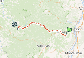

Length
77 km

Max alt
1372 m

Uphill gradient
1931 m
Km-Effort
100 km

Min alt
196 m

Downhill gradient
1080 m
Boucle
No
Creation date :
2024-07-09 18:18:02.807
Updated on :
2024-07-09 18:18:02.97

FREE GPS app for hiking
 SityTrail
IGN / Geographical institutes
SityTrail Plus
The world is yours!
About
Trail of 77 km to be discovered at Auvergne-Rhône-Alpes, Ardèche, Chomérac. This trail is proposed by oliviergau.
Positioning
Country:
France
Region :
Auvergne-Rhône-Alpes
Department/Province :
Ardèche
Municipality :
Chomérac
Location:
Unknown
Start:(Dec)
Start:(UTM)
631559 ; 4951905 (31T) N.
Comments