


est zərfi

bernir
User
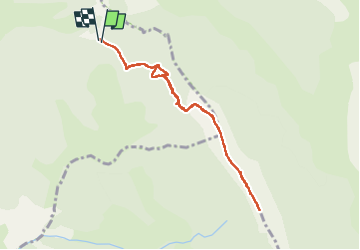

Length
8.3 km

Max alt
1736 m

Uphill gradient
479 m
Km-Effort
14.7 km

Min alt
1321 m

Downhill gradient
480 m
Boucle
Yes
Creation date :
2024-07-10 07:48:31.517
Updated on :
2024-07-11 06:50:42.76
3h19
Difficulty : Difficult

FREE GPS app for hiking
 SityTrail
IGN / Geographical institutes
SityTrail Plus
The world is yours!
About
Trail Walking of 8.3 km to be discovered at Provence-Alpes-Côte d'Azur, Alpes-de-Haute-Provence, Saint-Jurs. This trail is proposed by bernir.
Positioning
Country:
France
Region :
Provence-Alpes-Côte d'Azur
Department/Province :
Alpes-de-Haute-Provence
Municipality :
Saint-Jurs
Location:
Unknown
Start:(Dec)
Start:(UTM)
277920 ; 4865532 (32T) N.
Comments