


2024-07-10_18h11m09_sentier-local-vi-1

mumu.larandonneuse
User GUIDE
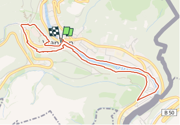

Length
4.9 km

Max alt
282 m

Uphill gradient
142 m
Km-Effort
6.8 km

Min alt
199 m

Downhill gradient
139 m
Boucle
Yes
Creation date :
2024-07-10 16:11:09.968
Updated on :
2024-07-10 16:13:02.652
1h33
Difficulty : Medium

FREE GPS app for hiking
 SityTrail
IGN / Geographical institutes
SityTrail Plus
The world is yours!
About
Trail Walking of 4.9 km to be discovered at Unknown, Canton Vianden, Vianden. This trail is proposed by mumu.larandonneuse.
Description
ℹ️ https://www.visitluxembourg.com/fr/tour/sentier-local-vi-1
Positioning
Country:
Luxembourg
Region :
Unknown
Department/Province :
Canton Vianden
Municipality :
Vianden
Location:
Unknown
Start:(Dec)
Start:(UTM)
299587 ; 5535003 (32U) N.
Comments