


Avril042024

FPortier
User
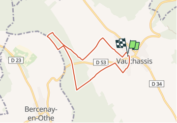

Length
6.9 km

Max alt
260 m

Uphill gradient
115 m
Km-Effort
8.4 km

Min alt
180 m

Downhill gradient
115 m
Boucle
Yes
Creation date :
2024-07-11 06:08:42.125
Updated on :
2024-07-11 06:09:14.064
1h54
Difficulty : Medium

FREE GPS app for hiking
 SityTrail
IGN / Geographical institutes
SityTrail Plus
The world is yours!
About
Trail Walking of 6.9 km to be discovered at Grand Est, Aube, Vauchassis. This trail is proposed by FPortier.
Positioning
Country:
France
Region :
Grand Est
Department/Province :
Aube
Municipality :
Vauchassis
Location:
Unknown
Start:(Dec)
Start:(UTM)
568466 ; 5341408 (31U) N.
Comments