


Le Travers

ARPF
User
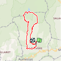

Length
17.9 km

Max alt
1332 m

Uphill gradient
735 m
Km-Effort
28 km

Min alt
711 m

Downhill gradient
730 m
Boucle
Yes
Creation date :
2015-04-24 00:00:00.0
Updated on :
2015-04-24 00:00:00.0
5h45
Difficulty : Difficult

FREE GPS app for hiking
 SityTrail
IGN / Geographical institutes
SityTrail Plus
The world is yours!
About
Trail Walking of 17.9 km to be discovered at Occitania, Gard, Aumessas. This trail is proposed by ARPF.
Description
PhG le 22/04/2015 P3 T2
Coef Effort : 83
Positioning
Country:
France
Region :
Occitania
Department/Province :
Gard
Municipality :
Aumessas
Location:
Unknown
Start:(Dec)
Start:(UTM)
541589 ; 4872582 (31T) N.
Comments