


navacelle 2

ARPF
User

Length
17.4 km

Max alt
669 m

Uphill gradient
518 m
Km-Effort
24 km

Min alt
326 m

Downhill gradient
519 m
Boucle
Yes
Creation date :
2015-04-24 00:00:00.0
Updated on :
2015-04-24 00:00:00.0
5h10
Difficulty : Unknown

FREE GPS app for hiking
 SityTrail
IGN / Geographical institutes
SityTrail Plus
The world is yours!
About
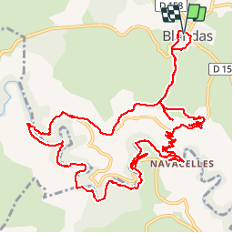
Trail Walking of 17.4 km to be discovered at Occitania, Gard, Blandas. This trail is proposed by ARPF.
Description
Cirque de Navacelle au départ de Blandas.
PhG 21/04/2015 P2 T2
Coef Effort: 74
Positioning
Country:
France
Region :
Occitania
Department/Province :
Gard
Municipality :
Blandas
Location:
Unknown
Start:(Dec)
Start:(UTM)
541116 ; 4862236 (31T) N.
Comments