


montbrand

xcreator
User
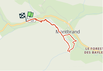

Length
3.8 km

Max alt
1015 m

Uphill gradient
90 m
Km-Effort
5.1 km

Min alt
960 m

Downhill gradient
93 m
Boucle
Yes
Creation date :
2024-07-11 11:41:05.403
Updated on :
2024-07-11 13:17:51.69
1h03
Difficulty : Easy

FREE GPS app for hiking
 SityTrail
IGN / Geographical institutes
SityTrail Plus
The world is yours!
About
Trail Walking of 3.8 km to be discovered at Provence-Alpes-Côte d'Azur, Hautes-Alpes, Montbrand. This trail is proposed by xcreator.
Photos


Positioning
Country:
France
Region :
Provence-Alpes-Côte d'Azur
Department/Province :
Hautes-Alpes
Municipality :
Montbrand
Location:
Unknown
Start:(Dec)
Start:(UTM)
711909 ; 4941088 (31T) N.
Comments