


SityTrail - 2024-04-20

Rando MLC
User
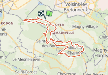

Length
19 km

Max alt
179 m

Uphill gradient
354 m
Km-Effort
24 km

Min alt
85 m

Downhill gradient
356 m
Boucle
Yes
Creation date :
2024-07-11 13:18:46.718
Updated on :
2024-11-11 10:06:46.542
5h23
Difficulty : Difficult

FREE GPS app for hiking
 SityTrail
IGN / Geographical institutes
SityTrail Plus
The world is yours!
About
Trail Walking of 19 km to be discovered at Ile-de-France, Yvelines, Magny-les-Hameaux. This trail is proposed by Rando MLC.
Positioning
Country:
France
Region :
Ile-de-France
Department/Province :
Yvelines
Municipality :
Magny-les-Hameaux
Location:
Unknown
Start:(Dec)
Start:(UTM)
427672 ; 5399959 (31U) N.
Comments