


travers

ARPF
User
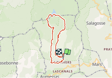

Length
17.9 km

Max alt
1332 m

Uphill gradient
736 m
Km-Effort
28 km

Min alt
711 m

Downhill gradient
730 m
Boucle
Yes
Creation date :
2015-04-24 00:00:00.0
Updated on :
2015-04-24 00:00:00.0
7h45
Difficulty : Difficult

FREE GPS app for hiking
 SityTrail
IGN / Geographical institutes
SityTrail Plus
The world is yours!
About
Trail Walking of 17.9 km to be discovered at Occitania, Gard, Aumessas. This trail is proposed by ARPF.
Positioning
Country:
France
Region :
Occitania
Department/Province :
Gard
Municipality :
Aumessas
Location:
Unknown
Start:(Dec)
Start:(UTM)
541589 ; 4872582 (31T) N.
Comments