


MARTINIQUE - FORET RABUCHON 8.6KM

jpb83
User
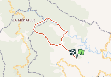

Length
8.6 km

Max alt
616 m

Uphill gradient
517 m
Km-Effort
15.5 km

Min alt
272 m

Downhill gradient
517 m
Boucle
Yes
Creation date :
2016-03-09 00:00:00.0
Updated on :
2016-03-09 00:00:00.0
3h07
Difficulty : Medium

FREE GPS app for hiking
 SityTrail
IGN / Geographical institutes
SityTrail Plus
The world is yours!
About
Trail Walking of 8.6 km to be discovered at Martinique, Unknown, Saint-Joseph. This trail is proposed by jpb83.
Positioning
Country:
France
Region :
Martinique
Department/Province :
Unknown
Municipality :
Saint-Joseph
Location:
Unknown
Start:(Dec)
Start:(UTM)
709146 ; 1623942 (20P) N.
Comments