Trail Walking La Chapelle-en-Valgaudémar - 
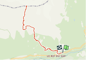
Refuge et Col de Chalance - Photo
 GAPIAN43
GAPIAN43

User

© OpenStreetMap contributors
Length
Length
12.9 km
Max alt
Max alt
3004 m
Uphill gradient
Uphill gradient
1608 m
Km-Effort
Km-Effort  
34 km
Min alt
Min alt
1431 m
Downhill gradient
Downhill gradient
1606 m
Boucle
Boucle
Yes
Creation date :
2024-07-11 18:12:50.009
Updated on :
2024-07-11 18:30:49.64

(0 Reviews)

Walking
Walking
7h47
Difficulty : Difficult

Scan this QR Code to open this trail in the SityTrail application

FREE GPS app for hiking

Logo SityTrail SityTrail

IGN / Geographical institutes

Download SityTrail from the App Store Download SityTrail from Google Play

Logo SityTrail SityTrail Plus

The world is yours!

Download SityTrail from the App Store Download SityTrail from Google Play Download SityTrail on Huawei AppGallery

About

Trail Walking of 12.9 km to be discovered at Provence-Alpes-Côte d'Azur, Hautes-Alpes, La Chapelle-en-Valgaudémar. This trail is proposed by GAPIAN43.

Description

Assez difficile en raison du dénivelé de la rando. Après la cabane de Chalance suivre les cairns. Seul petit passage délicat au dessus de la cote 2648 ou il faut revenir sur la droite pour passer une barre rocheuse. Ensuite à vue. Le col de Chalance ne permet pas de traverser vers le vallon de la Lavey. C’est la brèche de la Muande toute proche ou l’aiguille des Saffres encore un peu plus à l'est qui permettent ce passage.

Elevation profile

Positioning

Country:
France
Region :
Provence-Alpes-Côte d'Azur
Department/Province :
Hautes-Alpes
Municipality :
La Chapelle-en-Valgaudémar
Location:
Unknown
Start:(UTM)
283832 ; 4967508 (32T) N.


Close
My subscriptions