


Fond de gras

cravattep
User
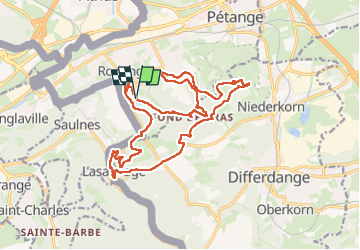

Length
20 km

Max alt
422 m

Uphill gradient
472 m
Km-Effort
27 km

Min alt
291 m

Downhill gradient
470 m
Boucle
Yes
Creation date :
2024-07-11 09:17:14.112
Updated on :
2024-07-11 18:23:03.388
4h04
Difficulty : Medium

FREE GPS app for hiking
 SityTrail
IGN / Geographical institutes
SityTrail Plus
The world is yours!
About
Trail Walking of 20 km to be discovered at Unknown, Canton Esch-sur-Alzette, Pétange. This trail is proposed by cravattep.
Positioning
Country:
Luxembourg
Region :
Unknown
Department/Province :
Canton Esch-sur-Alzette
Municipality :
Pétange
Location:
Rodange
Start:(Dec)
Start:(UTM)
705744 ; 5491200 (31U) N.
Comments