


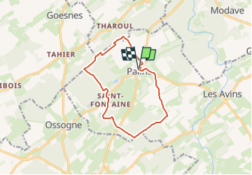
SityTrail - Circuit 9 de Pailhe à Saint-Fontaine "Cintfontaines et les étangs"

dejongm
User


3h04
Difficulty : Difficult

FREE GPS app for hiking
 SityTrail
IGN / Geographical institutes
SityTrail Plus
The world is yours!
About
Trail Walking of 10.8 km to be discovered at Wallonia, Liège, Clavier. This trail is proposed by dejongm.
Description
Randonnée créée par Terres-de-Meuse.
Belle balade forestière au départ de Pailhe (Clavier) qui vous fera découvrir le magnifique village de Cint ou Saint Fontaine et vous mènera sur le site du Maquis de bagatelle, haut lieu de la résistance durant la seconde guerre mondiale. C'est aussi l'occasion de découvrir le magnifique village de Saint Fontaine, déformation du qualificatif "cint", c'est à dire cent fontaines, en rapport avec les nombreuses sources qui alimentent rus et étangs dans le village.
Site web: https://organismes.tourismewallonie.be/details/ITB-01-000A7B&type=8/
Positioning
Comments