


EgliseNeuvedesLiards-Cunlhat

JackPG
User
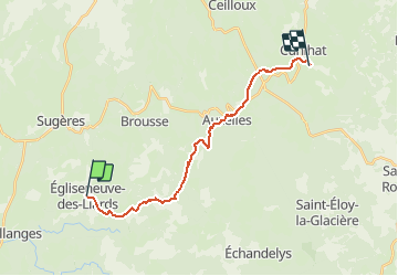

Length
18.2 km

Max alt
829 m

Uphill gradient
468 m
Km-Effort
24 km

Min alt
673 m

Downhill gradient
491 m
Boucle
No
Creation date :
2015-04-25 00:00:00.0
Updated on :
2015-04-25 00:00:00.0
5h12
Difficulty : Medium

FREE GPS app for hiking
 SityTrail
IGN / Geographical institutes
SityTrail Plus
The world is yours!
About
Trail Walking of 18.2 km to be discovered at Auvergne-Rhône-Alpes, Puy-de-Dôme, Égliseneuve-des-Liards. This trail is proposed by JackPG.
Positioning
Country:
France
Region :
Auvergne-Rhône-Alpes
Department/Province :
Puy-de-Dôme
Municipality :
Égliseneuve-des-Liards
Location:
Unknown
Start:(Dec)
Start:(UTM)
533081 ; 5046140 (31T) N.
Comments