


2024-07-13_07h22m04_export_24_07_13_072200

oliviergau
User
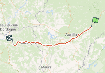

Length
77 km

Max alt
763 m

Uphill gradient
1069 m
Km-Effort
92 km

Min alt
151 m

Downhill gradient
1579 m
Boucle
No
Creation date :
2024-07-13 05:22:04.57
Updated on :
2024-07-13 05:22:04.167

FREE GPS app for hiking
 SityTrail
IGN / Geographical institutes
SityTrail Plus
The world is yours!
About
Trail of 77 km to be discovered at Auvergne-Rhône-Alpes, Cantal, Vic-sur-Cère. This trail is proposed by oliviergau.
Positioning
Country:
France
Region :
Auvergne-Rhône-Alpes
Department/Province :
Cantal
Municipality :
Vic-sur-Cère
Location:
Unknown
Start:(Dec)
Start:(UTM)
470557 ; 4980751 (31T) N.
Comments