


Etangs de Chalaire

meillon
User
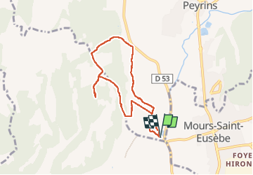

Length
7.2 km

Max alt
291 m

Uphill gradient
140 m
Km-Effort
9.1 km

Min alt
174 m

Downhill gradient
141 m
Boucle
Yes
Creation date :
2024-07-13 07:07:04.383
Updated on :
2024-07-13 09:37:07.545
2h29
Difficulty : Easy

FREE GPS app for hiking
 SityTrail
IGN / Geographical institutes
SityTrail Plus
The world is yours!
About
Trail Walking of 7.2 km to be discovered at Auvergne-Rhône-Alpes, Drôme, Peyrins. This trail is proposed by meillon.
Description
en passant par la combe de la Barniere
Positioning
Country:
France
Region :
Auvergne-Rhône-Alpes
Department/Province :
Drôme
Municipality :
Peyrins
Location:
Unknown
Start:(Dec)
Start:(UTM)
660434 ; 4992680 (31T) N.
Comments