


La boucle de foucher

sameja
User
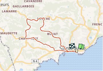

Length
10.7 km

Max alt
115 m

Uphill gradient
212 m
Km-Effort
13.5 km

Min alt
0 m

Downhill gradient
212 m
Boucle
Yes
Creation date :
2024-07-13 09:11:09.0
Updated on :
2024-07-13 11:27:30.979
1h16
Difficulty : Medium

FREE GPS app for hiking
 SityTrail
IGN / Geographical institutes
SityTrail Plus
The world is yours!
About
Trail Running of 10.7 km to be discovered at Guadeloupe, Unknown, Sainte-Anne. This trail is proposed by sameja.
Description
St Anne
Positioning
Country:
France
Region :
Guadeloupe
Department/Province :
Unknown
Municipality :
Sainte-Anne
Location:
Unknown
Start:(Dec)
Start:(UTM)
672839 ; 1794270 (20Q) N.
Comments