


Pic Saint Michel en circuit partiel

Emelle
User
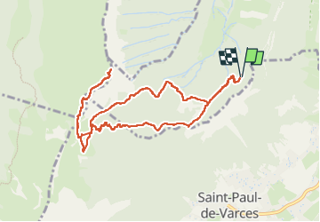

Length
11.7 km

Max alt
1965 m

Uphill gradient
833 m
Km-Effort
23 km

Min alt
1144 m

Downhill gradient
832 m
Boucle
Yes
Creation date :
2024-06-13 07:20:24.067
Updated on :
2024-07-13 13:01:56.149
3h58
Difficulty : Medium

FREE GPS app for hiking
 SityTrail
IGN / Geographical institutes
SityTrail Plus
The world is yours!
About
Trail Walking of 11.7 km to be discovered at Auvergne-Rhône-Alpes, Isère, Varces-Allières-et-Risset. This trail is proposed by Emelle.
Positioning
Country:
France
Region :
Auvergne-Rhône-Alpes
Department/Province :
Isère
Municipality :
Varces-Allières-et-Risset
Location:
Unknown
Start:(Dec)
Start:(UTM)
708157 ; 4996271 (31T) N.
Comments