


jour 2

Patrick Dewart
User

Length
15.2 km

Max alt
305 m

Uphill gradient
288 m
Km-Effort
18.6 km

Min alt
187 m

Downhill gradient
171 m
Boucle
No
Creation date :
2024-07-13 10:42:23.36
Updated on :
2024-07-13 15:06:06.634
4h21
Difficulty : Difficult

FREE GPS app for hiking
 SityTrail
IGN / Geographical institutes
SityTrail Plus
The world is yours!
About
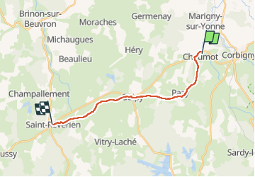
Trail Walking of 15.2 km to be discovered at Bourgogne-Franche-Comté, Nièvre, Chaumot. This trail is proposed by Patrick Dewart.
Description
genial
Photos


Positioning
Country:
France
Region :
Bourgogne-Franche-Comté
Department/Province :
Nièvre
Municipality :
Chaumot
Location:
Unknown
Start:(Dec)
Start:(UTM)
549017 ; 5234059 (31T) N.
Comments