


2024-07-13_22h35m06_export_24_07_13_223502

oliviergau
User
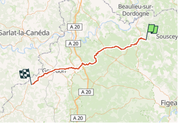

Length
71 km

Max alt
389 m

Uphill gradient
1251 m
Km-Effort
87 km

Min alt
135 m

Downhill gradient
1241 m
Boucle
No
Creation date :
2024-07-13 20:35:06.368
Updated on :
2024-07-13 20:35:08.957

FREE GPS app for hiking
 SityTrail
IGN / Geographical institutes
SityTrail Plus
The world is yours!
About
Trail of 71 km to be discovered at Occitania, Lot, Saint-Céré. This trail is proposed by oliviergau.
Positioning
Country:
France
Region :
Occitania
Department/Province :
Lot
Municipality :
Saint-Céré
Location:
Unknown
Start:(Dec)
Start:(UTM)
412608 ; 4967782 (31T) N.
Comments