


Cascade pointe de roche 15/07/24

th&jm
User
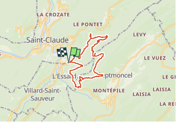

Length
15.7 km

Max alt
1097 m

Uphill gradient
993 m
Km-Effort
29 km

Min alt
441 m

Downhill gradient
989 m
Boucle
Yes
Creation date :
2024-07-15 06:45:13.0
Updated on :
2024-07-15 13:43:23.026

FREE GPS app for hiking
 SityTrail
IGN / Geographical institutes
SityTrail Plus
The world is yours!
About
Trail of 15.7 km to be discovered at Bourgogne-Franche-Comté, Jura, Villard-Saint-Sauveur. This trail is proposed by th&jm.
Positioning
Country:
France
Region :
Bourgogne-Franche-Comté
Department/Province :
Jura
Municipality :
Villard-Saint-Sauveur
Location:
Unknown
Start:(Dec)
Start:(UTM)
721452 ; 5139847 (31T) N.
Comments