


reconnaissance rando

evelyne10
User
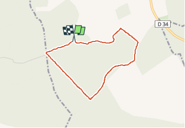

Length
3.3 km

Max alt
278 m

Uphill gradient
49 m
Km-Effort
3.9 km

Min alt
230 m

Downhill gradient
48 m
Boucle
Yes
Creation date :
2024-07-13 07:06:39.015
Updated on :
2024-07-16 06:36:43.33
1h12
Difficulty : Easy

FREE GPS app for hiking
 SityTrail
IGN / Geographical institutes
SityTrail Plus
The world is yours!
About
Trail Walking of 3.3 km to be discovered at Grand Est, Aube, Vauchassis. This trail is proposed by evelyne10.
Description
Balade reconnaissance
Positioning
Country:
France
Region :
Grand Est
Department/Province :
Aube
Municipality :
Vauchassis
Location:
Unknown
Start:(Dec)
Start:(UTM)
569074 ; 5338373 (31U) N.
Comments