


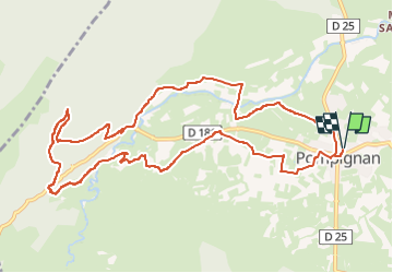
Pompignan - la Bergerie de Monier

JMJ42
User

Length
12.6 km

Max alt
428 m

Uphill gradient
317 m
Km-Effort
16.8 km

Min alt
179 m

Downhill gradient
317 m
Boucle
Yes
Creation date :
2024-07-16 09:52:21.809
Updated on :
2024-07-16 09:53:26.935
3h49
Difficulty : Medium

FREE GPS app for hiking
 SityTrail
IGN / Geographical institutes
SityTrail Plus
The world is yours!
About
Trail Walking of 12.6 km to be discovered at Occitania, Gard, Pompignan. This trail is proposed by JMJ42.
Positioning
Country:
France
Region :
Occitania
Department/Province :
Gard
Municipality :
Pompignan
Location:
Unknown
Start:(Dec)
Start:(UTM)
568854 ; 4860565 (31T) N.
Comments