


Chailland en suivant l'Ernée 12Km

JMCMoreau
User
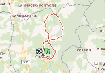

Length
12.1 km

Max alt
157 m

Uphill gradient
236 m
Km-Effort
15.3 km

Min alt
86 m

Downhill gradient
235 m
Boucle
Yes
Creation date :
2024-07-17 09:52:36.161
Updated on :
2024-07-17 09:54:49.404
3h30
Difficulty : Medium

FREE GPS app for hiking
 SityTrail
IGN / Geographical institutes
SityTrail Plus
The world is yours!
About
Trail Walking of 12.1 km to be discovered at Pays de la Loire, Mayenne, Chailland. This trail is proposed by JMCMoreau.
Positioning
Country:
France
Region :
Pays de la Loire
Department/Province :
Mayenne
Municipality :
Chailland
Location:
Unknown
Start:(Dec)
Start:(UTM)
658031 ; 5343318 (30U) N.
Comments
👌