


Sjc Aubigny-Pothee

erisel
User
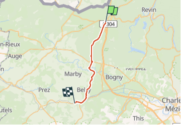

Length
22 km

Max alt
388 m

Uphill gradient
226 m
Km-Effort
25 km

Min alt
179 m

Downhill gradient
428 m
Boucle
No
Creation date :
2024-07-17 06:27:42.838
Updated on :
2024-07-17 16:15:05.262
9h46
Difficulty : Very difficult

FREE GPS app for hiking
 SityTrail
IGN / Geographical institutes
SityTrail Plus
The world is yours!
About
Trail Walking of 22 km to be discovered at Grand Est, Ardennes, Rocroi. This trail is proposed by erisel.
Positioning
Country:
France
Region :
Grand Est
Department/Province :
Ardennes
Municipality :
Rocroi
Location:
Unknown
Start:(Dec)
Start:(UTM)
609073 ; 5530951 (31U) N.
Comments