


rochers d'Argennes étang du Roy

olivieraron
User

Length
8.2 km

Max alt
181 m

Uphill gradient
115 m
Km-Effort
9.7 km

Min alt
144 m

Downhill gradient
126 m
Boucle
Yes
Creation date :
2024-07-18 06:55:26.857
Updated on :
2024-07-18 07:17:33.137
2h12
Difficulty : Medium

FREE GPS app for hiking
 SityTrail
IGN / Geographical institutes
SityTrail Plus
The world is yours!
About
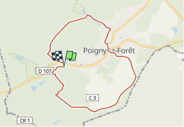
Trail Walking of 8.2 km to be discovered at Ile-de-France, Yvelines, Poigny-la-Forêt. This trail is proposed by olivieraron.
Positioning
Country:
France
Region :
Ile-de-France
Department/Province :
Yvelines
Municipality :
Poigny-la-Forêt
Location:
Unknown
Start:(Dec)
Start:(UTM)
407082 ; 5391775 (31U) N.
Comments