


Lyonnes

pb07
User
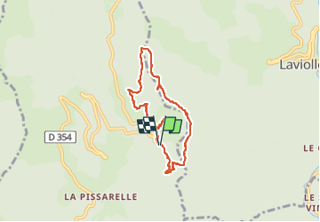

Length
6.5 km

Max alt
1327 m

Uphill gradient
156 m
Km-Effort
8.6 km

Min alt
1194 m

Downhill gradient
157 m
Boucle
Yes
Creation date :
2024-07-18 12:49:54.343
Updated on :
2024-07-18 16:26:23.051
2h15
Difficulty : Medium

FREE GPS app for hiking
 SityTrail
IGN / Geographical institutes
SityTrail Plus
The world is yours!
About
Trail Walking of 6.5 km to be discovered at Auvergne-Rhône-Alpes, Ardèche, Labastide-sur-Bésorgues. This trail is proposed by pb07.
Positioning
Country:
France
Region :
Auvergne-Rhône-Alpes
Department/Province :
Ardèche
Municipality :
Labastide-sur-Bésorgues
Location:
Unknown
Start:(Dec)
Start:(UTM)
603782 ; 4956154 (31T) N.
Comments