


19_7_24

baudon
User
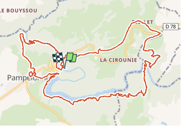

Length
19.5 km

Max alt
492 m

Uphill gradient
704 m
Km-Effort
29 km

Min alt
265 m

Downhill gradient
704 m
Boucle
Yes
Creation date :
2024-07-19 06:16:31.323
Updated on :
2024-07-19 14:34:29.552
8h12
Difficulty : Very difficult

FREE GPS app for hiking
 SityTrail
IGN / Geographical institutes
SityTrail Plus
The world is yours!
About
Trail Walking of 19.5 km to be discovered at Occitania, Tarn, Pampelonne. This trail is proposed by baudon.
Positioning
Country:
France
Region :
Occitania
Department/Province :
Tarn
Municipality :
Pampelonne
Location:
Unknown
Start:(Dec)
Start:(UTM)
440581 ; 4886142 (31T) N.
Comments