


Brasles

explorateur
User

Length
9 km

Max alt
219 m

Uphill gradient
172 m
Km-Effort
11.5 km

Min alt
74 m

Downhill gradient
218 m
Boucle
No
Creation date :
2024-07-19 12:55:49.238
Updated on :
2024-07-19 16:14:23.873
3h16
Difficulty : Medium

FREE GPS app for hiking
 SityTrail
IGN / Geographical institutes
SityTrail Plus
The world is yours!
About
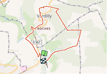
Trail Walking of 9 km to be discovered at Hauts-de-France, Aisne, Brasles. This trail is proposed by explorateur.
Positioning
Country:
France
Region :
Hauts-de-France
Department/Province :
Aisne
Municipality :
Brasles
Location:
Unknown
Start:(Dec)
Start:(UTM)
530857 ; 5433832 (31U) N.
Comments