


Sancy depuis la station Chastreix Sancy

Chabard
User
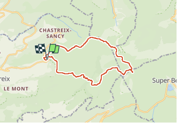

Length
15.8 km

Max alt
1862 m

Uphill gradient
719 m
Km-Effort
25 km

Min alt
1307 m

Downhill gradient
720 m
Boucle
Yes
Creation date :
2024-07-20 05:45:01.0
Updated on :
2024-07-20 13:48:40.447
5h45
Difficulty : Difficult

FREE GPS app for hiking
 SityTrail
IGN / Geographical institutes
SityTrail Plus
The world is yours!
About
Trail Walking of 15.8 km to be discovered at Auvergne-Rhône-Alpes, Puy-de-Dôme, Chastreix. This trail is proposed by Chabard.
Description
Roc de Courlande - Mont Redon - Col de Courre - Puy de Sancy - Col de la Cabane - Col de Couhay
Positioning
Country:
France
Region :
Auvergne-Rhône-Alpes
Department/Province :
Puy-de-Dôme
Municipality :
Chastreix
Location:
Unknown
Start:(Dec)
Start:(UTM)
482059 ; 5040913 (31T) N.
Comments