


morbier 15 km

daniellebou
User
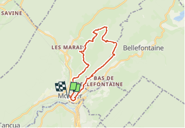

Length
15.2 km

Max alt
1155 m

Uphill gradient
488 m
Km-Effort
22 km

Min alt
814 m

Downhill gradient
488 m
Boucle
Yes
Creation date :
2024-07-20 08:26:40.769
Updated on :
2024-07-25 23:48:03.125
3h47
Difficulty : Very difficult

FREE GPS app for hiking
 SityTrail
IGN / Geographical institutes
SityTrail Plus
The world is yours!
About
Trail Walking of 15.2 km to be discovered at Bourgogne-Franche-Comté, Jura, Morbier. This trail is proposed by daniellebou.
Positioning
Country:
France
Region :
Bourgogne-Franche-Comté
Department/Province :
Jura
Municipality :
Morbier
Location:
Unknown
Start:(Dec)
Start:(UTM)
271142 ; 5157821 (32T) N.
Comments