


Thon

chifmichel
User GUIDE
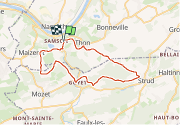

Length
14 km

Max alt
221 m

Uphill gradient
405 m
Km-Effort
19.4 km

Min alt
84 m

Downhill gradient
403 m
Boucle
Yes
Creation date :
2024-07-21 08:04:05.0
Updated on :
2024-07-21 11:19:43.506
2h46
Difficulty : Very difficult

FREE GPS app for hiking
 SityTrail
IGN / Geographical institutes
SityTrail Plus
The world is yours!
About
Trail Walking of 14 km to be discovered at Wallonia, Namur, Andenne. This trail is proposed by chifmichel.
Description
Marche
Positioning
Country:
Belgium
Region :
Wallonia
Department/Province :
Namur
Municipality :
Andenne
Location:
Thon
Start:(Dec)
Start:(UTM)
641979 ; 5592208 (31U) N.
Comments