


montcornet ffsp

grmb
User
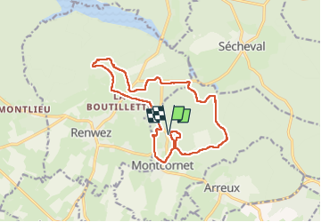

Length
14.5 km

Max alt
342 m

Uphill gradient
262 m
Km-Effort
18 km

Min alt
250 m

Downhill gradient
261 m
Boucle
Yes
Creation date :
2024-07-21 08:03:27.377
Updated on :
2024-07-21 12:09:48.561
4h06
Difficulty : Difficult

FREE GPS app for hiking
 SityTrail
IGN / Geographical institutes
SityTrail Plus
The world is yours!
About
Trail Walking of 14.5 km to be discovered at Grand Est, Ardennes, Montcornet. This trail is proposed by grmb.
Positioning
Country:
France
Region :
Grand Est
Department/Province :
Ardennes
Municipality :
Montcornet
Location:
Unknown
Start:(Dec)
Start:(UTM)
617327 ; 5521931 (31U) N.
Comments