


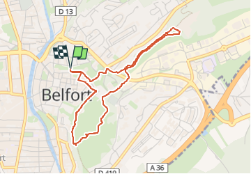
Citadelle de Belfort

Bart2015
User

Length
4.3 km

Max alt
428 m

Uphill gradient
82 m
Km-Effort
5.3 km

Min alt
360 m

Downhill gradient
82 m
Boucle
Yes
Creation date :
2024-07-21 19:10:54.352
Updated on :
2024-07-29 09:00:53.929
1h12
Difficulty : Easy

FREE GPS app for hiking
 SityTrail
IGN / Geographical institutes
SityTrail Plus
The world is yours!
About
Trail Walking of 4.3 km to be discovered at Bourgogne-Franche-Comté, Territoire-de-Belfort, Belfort. This trail is proposed by Bart2015.
Description
Petite balade dans la citadelle de Belfort à faire de préférence en début de nuit avec des frontales pour l'ambiance ...
Bone balade, soyez prudents ...
Positioning
Country:
France
Region :
Bourgogne-Franche-Comté
Department/Province :
Territoire-de-Belfort
Municipality :
Belfort
Location:
Unknown
Start:(Dec)
Start:(UTM)
339522 ; 5278512 (32T) N.
Comments