


2024-07-22_11h14m55_vassieux V2 Petite

AnaisLambert
User
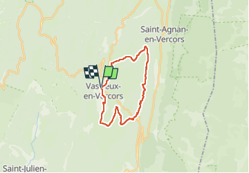

Length
22 km

Max alt
1267 m

Uphill gradient
437 m
Km-Effort
27 km

Min alt
1036 m

Downhill gradient
437 m
Boucle
Yes
Creation date :
2024-07-22 09:14:55.652
Updated on :
2024-09-26 20:08:13.57
0m
Difficulty : Medium

FREE GPS app for hiking
 SityTrail
IGN / Geographical institutes
SityTrail Plus
The world is yours!
About
Trail Coupling of 22 km to be discovered at Auvergne-Rhône-Alpes, Drôme, Vassieux-en-Vercors. This trail is proposed by AnaisLambert.
Positioning
Country:
France
Region :
Auvergne-Rhône-Alpes
Department/Province :
Drôme
Municipality :
Vassieux-en-Vercors
Location:
Unknown
Start:(Dec)
Start:(UTM)
687058 ; 4974239 (31T) N.
Comments