


st sulpice mauchampd

Auger91
User
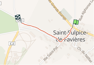

Length
385 m

Max alt
96 m

Uphill gradient
4 m
Km-Effort
428 m

Min alt
91 m

Downhill gradient
1 m
Boucle
No
Creation date :
2024-07-23 09:57:30.659
Updated on :
2024-07-23 10:04:27.517
6m
Difficulty : Easy

FREE GPS app for hiking
 SityTrail
IGN / Geographical institutes
SityTrail Plus
The world is yours!
About
Trail Walking of 385 m to be discovered at Ile-de-France, Essonne, Saint-Sulpice-de-Favières. This trail is proposed by Auger91.
Positioning
Country:
France
Region :
Ile-de-France
Department/Province :
Essonne
Municipality :
Saint-Sulpice-de-Favières
Location:
Unknown
Start:(Dec)
Start:(UTM)
439377 ; 5376835 (31U) N.
Comments