


Hohnstein cap

LauVan
User
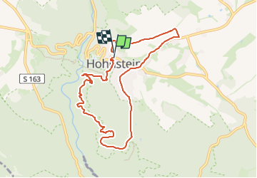

Length
8 km

Max alt
363 m

Uphill gradient
204 m
Km-Effort
10.6 km

Min alt
247 m

Downhill gradient
189 m
Boucle
Yes
Creation date :
2024-07-23 13:56:41.979
Updated on :
2024-07-23 14:45:41.392
48m
Difficulty : Easy

FREE GPS app for hiking
 SityTrail
IGN / Geographical institutes
SityTrail Plus
The world is yours!
About
Trail Running of 8 km to be discovered at Saxony, Sächsische Schweiz-Osterzgebirge, Hohnstein. This trail is proposed by LauVan.
Positioning
Country:
Germany
Region :
Saxony
Department/Province :
Sächsische Schweiz-Osterzgebirge
Municipality :
Hohnstein
Location:
Unknown
Start:(Dec)
Start:(UTM)
437594 ; 5648039 (33U) N.
Comments