


2024-07-23_20h26m34_G 12

LUTZMarc
User
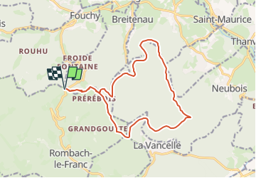

Length
15.4 km

Max alt
747 m

Uphill gradient
491 m
Km-Effort
22 km

Min alt
474 m

Downhill gradient
490 m
Boucle
Yes
Creation date :
2024-07-23 18:26:34.89
Updated on :
2024-11-01 08:39:41.309
4h59
Difficulty : Easy

FREE GPS app for hiking
 SityTrail
IGN / Geographical institutes
SityTrail Plus
The world is yours!
About
Trail Walking of 15.4 km to be discovered at Grand Est, Bas-Rhin, Breitenau. This trail is proposed by LUTZMarc.
Positioning
Country:
France
Region :
Grand Est
Department/Province :
Bas-Rhin
Municipality :
Breitenau
Location:
Unknown
Start:(Dec)
Start:(UTM)
371002 ; 5351649 (32U) N.
Comments