


paris sommets

olivieraron
User
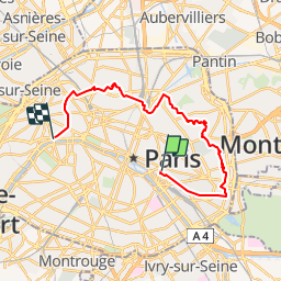

Length
21 km

Max alt
126 m

Uphill gradient
330 m
Km-Effort
25 km

Min alt
34 m

Downhill gradient
327 m
Boucle
No
Creation date :
2019-01-14 09:45:55.457
Updated on :
2019-01-14 09:45:55.463
6h00
Difficulty : Unknown

FREE GPS app for hiking
 SityTrail
IGN / Geographical institutes
SityTrail Plus
The world is yours!
About
Trail Other activity of 21 km to be discovered at Ile-de-France, Paris, Paris. This trail is proposed by olivieraron.
Positioning
Country:
France
Region :
Ile-de-France
Department/Province :
Paris
Municipality :
Paris
Location:
12th Arrondissement
Start:(Dec)
Start:(UTM)
453679 ; 5411120 (31U) N.
Comments