Trail On foot Saint-Germain-en-Laye - De St Germain en Laye au château de Montecristo et retour n°2 - Photo

De St Germain en Laye au château de Montecristo et retour n°2

 Surot
Surot

User

© OpenStreetMap contributors
Length
Length
13.3 km
Max alt
Max alt
97 m
Uphill gradient
Uphill gradient
214 m
Km-Effort
Km-Effort  
16.2 km
Min alt
Min alt
21 m
Downhill gradient
Downhill gradient
213 m
Boucle
Boucle
Yes
Creation date :
2024-07-25 12:43:30.001
Updated on :
2024-08-26 08:16:44.738

(0 Reviews)

On foot
On foot
3h40
Difficulty : Easy

Scan this QR Code to open this trail in the SityTrail application

FREE GPS app for hiking

Logo SityTrail SityTrail

IGN / Geographical institutes

Download SityTrail from the App Store Download SityTrail from Google Play

Logo SityTrail SityTrail Plus

The world is yours!

Download SityTrail from the App Store Download SityTrail from Google Play Download SityTrail on Huawei AppGallery

About

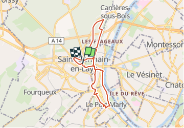
Trail On foot of 13.3 km to be discovered at Ile-de-France, Yvelines, Saint-Germain-en-Laye. This trail is proposed by Surot.

Description

Trajet en partie en ville,   parc du château et picnic, puis par le chemin des grottes et routes tranquilles souvent  avec trottoirs vers le chemin du raidillon, rue C. de Gaulle , passage souterrain vers le vieux chemin de Marly, le chemin des Montferrand au bout et le château, indiqué, puis reprendre ce chemin vers Port-Marly où, au feu, on rejoint la rue Jean Jaurès puis le chemin des bords de Seine jusqu'au bd Brossolette sur qq m  pour retourner à G vers St Germain par la rue de Paris, le passage des grottes, l'Av. Thiers et le RER! 11km  environ

Elevation profile

Positioning

Country:
France
Region :
Ile-de-France
Department/Province :
Yvelines
Municipality :
Saint-Germain-en-Laye
Location:
Saint-Germain-en-Laye
Start:(UTM)
433570 ; 5416644 (31U) N.


Close
My subscriptions