


Sentier de la rouge Saissac

caccini
User
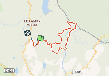

Length
8.3 km

Max alt
656 m

Uphill gradient
136 m
Km-Effort
10.1 km

Min alt
575 m

Downhill gradient
130 m
Boucle
No
Creation date :
2024-07-25 07:08:25.709
Updated on :
2024-07-26 08:35:10.753
2h18
Difficulty : Easy

FREE GPS app for hiking
 SityTrail
IGN / Geographical institutes
SityTrail Plus
The world is yours!
About
Trail Walking of 8.3 km to be discovered at Occitania, Aude, Saissac. This trail is proposed by caccini.
Description
C'est une très jolie randonnée d'été fraiche ombragée charmante.
Positioning
Country:
France
Region :
Occitania
Department/Province :
Aude
Municipality :
Saissac
Location:
Unknown
Start:(Dec)
Start:(UTM)
432612 ; 4803827 (31T) N.
Comments