


champey

jacthiry
User
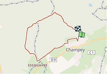

Length
7.3 km

Max alt
536 m

Uphill gradient
205 m
Km-Effort
10 km

Min alt
356 m

Downhill gradient
191 m
Boucle
No
Creation date :
2024-07-25 11:52:36.19
Updated on :
2024-07-25 14:33:35.743
2h40
Difficulty : Medium

FREE GPS app for hiking
 SityTrail
IGN / Geographical institutes
SityTrail Plus
The world is yours!
About
Trail Walking of 7.3 km to be discovered at Bourgogne-Franche-Comté, Haute-Saône, Champey. This trail is proposed by jacthiry.
Positioning
Country:
France
Region :
Bourgogne-Franche-Comté
Department/Province :
Haute-Saône
Municipality :
Champey
Location:
Unknown
Start:(Dec)
Start:(UTM)
325710 ; 5273101 (32T) N.
Comments