


Moutiers - Source de la loue - belvédères

daniellebou
User
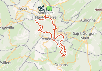

Length
20 km

Max alt
785 m

Uphill gradient
800 m
Km-Effort
31 km

Min alt
377 m

Downhill gradient
801 m
Boucle
Yes
Creation date :
2024-07-25 07:32:13.991
Updated on :
2024-07-26 21:44:55.364
5h13
Difficulty : Very difficult

FREE GPS app for hiking
 SityTrail
IGN / Geographical institutes
SityTrail Plus
The world is yours!
About
Trail Walking of 20 km to be discovered at Bourgogne-Franche-Comté, Doubs, Mouthier-Haute-Pierre. This trail is proposed by daniellebou.
Positioning
Country:
France
Region :
Bourgogne-Franche-Comté
Department/Province :
Doubs
Municipality :
Mouthier-Haute-Pierre
Location:
Unknown
Start:(Dec)
Start:(UTM)
292992 ; 5213225 (32T) N.
Comments