


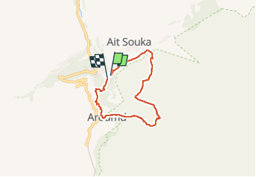
Imlil

JMHRX2
User

Length
6.8 km

Max alt
2162 m

Uphill gradient
383 m
Km-Effort
12 km

Min alt
1769 m

Downhill gradient
403 m
Boucle
Yes
Creation date :
2024-07-15 08:04:10.776
Updated on :
2024-07-27 16:33:36.114
3h18
Difficulty : Medium

FREE GPS app for hiking
 SityTrail
IGN / Geographical institutes
SityTrail Plus
The world is yours!
About
Trail Walking of 6.8 km to be discovered at Marrakech-Safi, cercle d'Asni, Asni. This trail is proposed by JMHRX2.
Positioning
Country:
Morocco
Region :
Marrakech-Safi
Department/Province :
cercle d'Asni
Municipality :
Asni
Location:
Unknown
Start:(Dec)
Start:(UTM)
603331 ; 3445006 (29R) N.
Comments