


Taroudant

JMHRX2
User
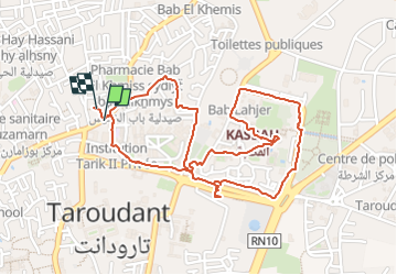

Length
3.4 km

Max alt
244 m

Uphill gradient
15 m
Km-Effort
3.6 km

Min alt
237 m

Downhill gradient
15 m
Boucle
Yes
Creation date :
2024-07-15 18:15:32.832
Updated on :
2024-07-27 16:33:38.872
1h06
Difficulty : Easy

FREE GPS app for hiking
 SityTrail
IGN / Geographical institutes
SityTrail Plus
The world is yours!
About
Trail Walking of 3.4 km to be discovered at Souss-Massa, Pachalik de Taroudant, Taroudant. This trail is proposed by JMHRX2.
Positioning
Country:
Morocco
Region :
Souss-Massa
Department/Province :
Pachalik de Taroudant
Municipality :
Taroudant
Location:
Unknown
Start:(Dec)
Start:(UTM)
511707 ; 3371347 (29R) N.
Comments