


Lembach-Col de Riegelsberg-Lembach

maureengeorges
User
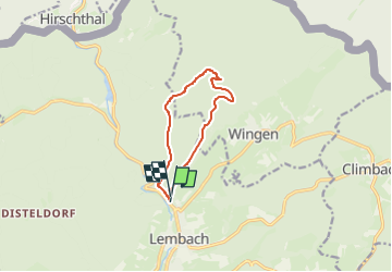

Length
8.4 km

Max alt
459 m

Uphill gradient
289 m
Km-Effort
12.2 km

Min alt
219 m

Downhill gradient
265 m
Boucle
Yes
Creation date :
2024-07-28 09:46:51.609
Updated on :
2024-07-28 09:46:54.985
2h46
Difficulty : Difficult

FREE GPS app for hiking
 SityTrail
IGN / Geographical institutes
SityTrail Plus
The world is yours!
About
Trail Walking of 8.4 km to be discovered at Grand Est, Bas-Rhin, Lembach. This trail is proposed by maureengeorges.
Positioning
Country:
France
Region :
Grand Est
Department/Province :
Bas-Rhin
Municipality :
Lembach
Location:
Unknown
Start:(Dec)
Start:(UTM)
411312 ; 5429427 (32U) N.
Comments