


Sainte Croix fontaine des Bazis

pidjam
User
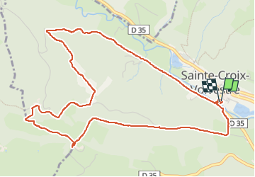

Length
6.8 km

Max alt
467 m

Uphill gradient
208 m
Km-Effort
9.5 km

Min alt
300 m

Downhill gradient
207 m
Boucle
Yes
Creation date :
2024-07-28 06:31:48.935
Updated on :
2024-07-28 12:42:07.61
1h46
Difficulty : Easy

FREE GPS app for hiking
 SityTrail
IGN / Geographical institutes
SityTrail Plus
The world is yours!
About
Trail Walking of 6.8 km to be discovered at Occitania, Ariège, Sainte-Croix-Volvestre. This trail is proposed by pidjam.
Positioning
Country:
France
Region :
Occitania
Department/Province :
Ariège
Municipality :
Sainte-Croix-Volvestre
Location:
Unknown
Start:(Dec)
Start:(UTM)
351514 ; 4776279 (31T) N.
Comments