


Tracé 004

tercla
User
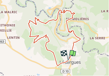

Length
11.7 km

Max alt
502 m

Uphill gradient
461 m
Km-Effort
17.8 km

Min alt
354 m

Downhill gradient
463 m
Boucle
Yes
Creation date :
2024-07-29 11:54:36.419
Updated on :
2024-07-29 12:18:55.258
4h03
Difficulty : Difficult

FREE GPS app for hiking
 SityTrail
IGN / Geographical institutes
SityTrail Plus
The world is yours!
About
Trail Walking of 11.7 km to be discovered at Occitania, Aveyron, Lédergues. This trail is proposed by tercla.
Positioning
Country:
France
Region :
Occitania
Department/Province :
Aveyron
Municipality :
Lédergues
Location:
Unknown
Start:(Dec)
Start:(UTM)
455183 ; 4881862 (31T) N.
Comments