


Lac Pavin

martin.mondeville
User
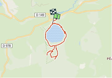

Length
7.3 km

Max alt
1398 m

Uphill gradient
222 m
Km-Effort
10.3 km

Min alt
1168 m

Downhill gradient
252 m
Boucle
No
Creation date :
2024-07-29 13:22:54.0
Updated on :
2024-07-29 16:25:32.127

FREE GPS app for hiking
 SityTrail
IGN / Geographical institutes
SityTrail Plus
The world is yours!
About
Trail of 7.3 km to be discovered at Auvergne-Rhône-Alpes, Puy-de-Dôme, Besse-et-Saint-Anastaise. This trail is proposed by martin.mondeville.
Positioning
Country:
France
Region :
Auvergne-Rhône-Alpes
Department/Province :
Puy-de-Dôme
Municipality :
Besse-et-Saint-Anastaise
Location:
Besse
Start:(Dec)
Start:(UTM)
491138 ; 5038488 (31T) N.
Comments