


soulor

sdroneau
User
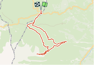

Length
10.9 km

Max alt
2217 m

Uphill gradient
788 m
Km-Effort
21 km

Min alt
1460 m

Downhill gradient
787 m
Boucle
Yes
Creation date :
2024-07-29 06:20:54.86
Updated on :
2024-07-29 18:50:55.486
4h30
Difficulty : Very difficult

FREE GPS app for hiking
 SityTrail
IGN / Geographical institutes
SityTrail Plus
The world is yours!
About
Trail Walking of 10.9 km to be discovered at Occitania, Hautespyrenees, Arbéost. This trail is proposed by sdroneau.
Positioning
Country:
France
Region :
Occitania
Department/Province :
Hautespyrenees
Municipality :
Arbéost
Location:
Unknown
Start:(Dec)
Start:(UTM)
723334 ; 4760252 (30T) N.
Comments